It snowed on the Continental Divide in Colorado yesterday. The aspens are turning a brilliant yellow. Elk bugles echo in the lower meadows. I'm sad to see the summer come to an end. It's been a good one, really the best one ever.
I've had summers where I've hiked more days. I've had summers where I've worked less hours. But I've never had a summer where I've had a chance to touch the lives, if only briefly, of so many people. People who love hiking and the outdoors, and people who are so passionate about a protecting a trail stringing through the Rocky Mountains.
Thanks to all of you, we've achieved unthinkable goals in the past four months. We have the most up-to-date information on the CDT in the world. We believe the data our CDT map scouts collected is better than what land managers and CDTA currently house on their systems. To echo the words of Teresa Martinez, Field Operations Manager of the CDTA, "you've started a legacy."
I like that.
I'll also admit this project didn't come without shortfalls. The schwag promised hasn't been shipped (we intend to honor our promise to reward our CDT volunteers), three teams didn't get their section maps, two teams dissolved from conflicting personalities, and wildfires displaced more than 25 volunteers. The sale of Backpacker to Active Interest Media caused delays and staff shortfall in every department.
The good news is our CDT teams have managed to map more than 2,000 miles of trail this summer. Real progress has been made, and will continue to be made next summer. Yep, you heard it here, we're going to continue the project next year. We'll keep updates posted on this blog.
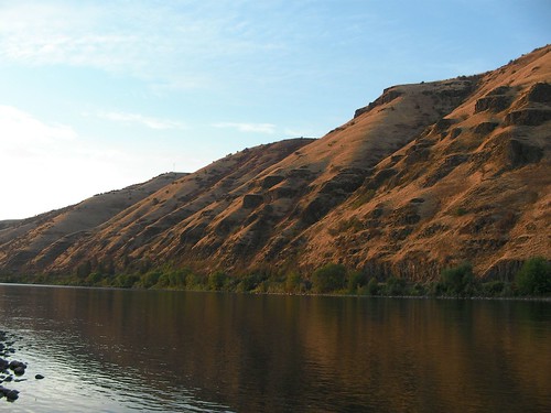
Photo: Sunrise at Ute Lake. Submitted by Pam Johns of Team 16.
This is an exciting time--and one of the most memorable of my career so far. In the past few weeks, we've seen hundreds of photos from several segments of the Continental Divide Trail. The result of this project is coming alive in front of our eyes as we begin to edit sections, doubleback with land mangers, and, most importantly, assemble all the great stories, field notes, and media everyone has collected. All that talk, all those logistics, all those phone calls and emails were worth it. It's going to take weeks to put it all together, and if you haven't heard from us you will soon.
In the meantime, we'll be posting short reports and an appetizer of photos here, and we'll be catching up on a backlog of emails from team leaders. Just a few hours ago Jonathan Ellinger sent me an email:
"We finished last Saturday our trip from Big Hole Pass to Goldstone. My blog entry for the trip is here." Cool blog Jonathan! You can see photos from the trip on Flickr too.
Eli Schelin emailed us a short report this afternoon on their scout of the most northern 50 miles of the CDT.
"We covered the 52 miles from Waterton, Alberta, Canada to the Jackson Glacier Overlook. The trail is in excellent shape and is well signed. We saw lots of wildlife – deer, long horn sheep, and mountain goats in the campsites and on the trail. And we even saw a snow flurry as we came across Piegan Pass on the 8/23. All the team members did a great job supporting one another and sharing their skills and knowledge.
We have a ton of pictures that everyone is sorting through – but in the mean time I’ve attached one picture of the search party at the trailhead in Waterton, Alberta, Canada on the 8/19. From left to right are Andy Hubing, Brian & Shelley TerBush, Robert Vanderhoof, and Eli Schelin."
Check these photos out! Keith Gebo sent these in today from Team 49 on the CDT in Montana. There fires surround them for most of the trip. "We should have some great shots of a big grizzly bruin. The smoke kept us from getting very many 'Big Sky' photos," say Keith. "There were some serious issues with the trail markers and the trail conditions to a lesser extent. I used a MP3 voice recorder to document the trail conditions and warnings. I am working on transcribing it. When I finish I'll send a copy to you. I will also be sharing the information with the local USFS." Thanks for the update Keith.
Here's a new twist: Over the next two years Glenn Dunmire plans to backpack, scramble, climb, or do whatever it takes to trace the Continental Divide.
Not the trail, but the Divide itself.
His hope is to straddle the entire backbone from Mexico to Canada. Most of it will be off-trail, and some hairball sections will require X-treme climbing skills on rotten rock. Most of the trip he'll do solo, too.
Oh yeah, and according to his website, Glenn is doing this truly epic adventure on a rehabilitated hand with three missing carpal bones and a crippled left knee with "no ACL or medial or lateral meniscus."
Imagine the logistics to work a trip like this out? Imagine the all the T-storms he'll have to face being above treeline most of the time? Good luck, Glenn, we'll be watching.
Since our last blog on the Helena High Boys (Team 48), the team has successfully completed their 42-mile section. Listen to the rest of their adventure unfold below:
AUGUST 15 (DAY 3) In this two-part podcast on Day 3, team leader Steve Wargo reports a few blisters but overall three great days. Tonight they camp at 7,800 feet under the shadow of Mount Black in grizzly country. They also talked about their encounter with The Onion, the thru-hiker who plans to yo-yo the trail this year.
First Report
Second Report
AUGUST 16 (DAY 4) "Today has been absolutely spectacular!" The team tagged several peaks today, including the highpoint on their section. GPS location: 12T 0383937E 5183942N.
AUGUST 17 (DAY 5) The five High Boys arrive back in Helena, MT. Team leader Steve reviews how they mapped some of the tough areas of their section and they have a lot of suggestions for land managers and BACKPACKER. In addition to other highlights and last thoughts about their trip, Steve tells a funny story on how a CDT sign clocked one of the High Boys in the head on their last night.
Team co-leader and frequent map contributor Leon Nelson of Redding, CA sent in these photos from their 50-mile leg in the Wind River Range of Bridger-Teton National Forest last week. Leon says the elevation proved to be the biggest challenge for the group who all came from hometowns well below 1,000 ft (the trailhead was over 9,000 ft.). Leon plans to call in day-by-day podcast reports later this week to re-cap their adventures. Send us more photos too, Leon!
Have you heard of this guy? Garret Christensen (trail name: The Onion) is attempting to yo-yo the CDT this year. That means he'll hike from Mexico to Canada then turn around and hike back to Mexico for a total of roughly 6,200 miles. Team 48 crossed paths with this speedhiker yesterday in Helena National Forest. By 5 p.m., The Onion already had 20 miles under his belt for the day and said he finished his north-bound hike in an impressive 95 days. He was on Day 105 or 106 and heading back to Mexico. So he's hiking about 33 miles a day, plus more miles on re-supply days. You can follow his progress on his blog.
This quick report came in last night from Sean Bullington of Centreville, VA:
"Just wanted to send you a quick update to let you know that we are back from the trip (we got in from Jackson, WY this past Sunday morning). We're sifting through the pics/etc and will be working on the trip report over the next week. Other than some blisters, having longer days than expected, walking through some good storms, seeing tons of wildlife, and having to re-route around a grizzly eating a horse on the trail, the trip went really smoothly! We'll keep you posted as the report gets finished, and here's a pic of us near some thermals on the way to Heart Lake!" Thanks for the great attitude and help, AWA!
From a windy saddle, Steve Wargo hells out a big thanks to David Payne and Michael Brown who helped his team through a parched and unsigned section of the CDT yesterday in Helena National Forest, Montana. The team completed 11 miles yesterday, and plans to hike 8 today. Listen to podcast below.
"Our team set out last Sunday, August 5th to map a 67-mile stretch of the Continental Divide Trail in Colorado. After three days of steady rain and drizzle, the clouds lifted just in time for the high-altitude portion of the trip. The remaining three days were spent at 12,000+ feet, navigating exposed ridgelines and gaping at the dramatic RockyMountain views. Although the rugged terrain caused a few injuries, our group persevered, summited the final peak of the trip (14,270-ft. Grays Peak), and finished in Bakerville." More photos below:
This report and photos just came in from Todd Fontaine of Team 20.
"Group 20CO, aka Skywalkers, finished their section of trail on August 4th. Our trip brought us through some parts of the CDT that were currently under construction as well as across the well-established Monarch Crest section. With the help of Mal Sillars (CDT surveyor), who joined us for the first two days, we were able to map approximately 12+ miles of the soon to be CDT. We had decided to go with light packs for there were sections that hadn't been established yet. This meant crossing talus and scree fields as well as navigating our way through sections of brush, but the payoff was amazing. Once we hit the completed trail we were able to really appreciate all the work that goes into trail construction. Our group met up with a couple of crews and their work was truly incredible. The next three days we hucked our heavy packs up and over Chalk Creek Pass, past Hunt Lake and then to Monarch Pass. Due to some time constraints and a desire to beat the hordes of mountain bikers on the Monarch Crest Trail, we dumped our heavy packs and decided to blast out the 11 or so miles with light packs to finish at Marshall Pass."
Steve Wargo of Team 48 (Helena Highboys) reported in this morning from MacDonald Pass about 14.5 miles west of Helena, MT. Steve, as you might remember, submitted a YouTube application early this spring, so we're expecting lots of exciting coverage from the team. The team was briefed by Montana Wilderness Society this past weekend, and is joined by a local Forest Service expert today. This difficult section will require keen navigation skills. Listen below:
Naomi Blagdon recaps their adventure on the CDT last week. Their 60-mile section, including a 2-mile reroute to avoid a problematic bear, stringed together Yellowstone National Park and Teton Wilderness. Listen in as she lists all the wildlife and beautiful scenery they saw, plus the unique characters on the trail, including thru-hikers and cowboys.
This week we find four more teams on the trail. They are:
Team 23 This trio will hike a 38-mile segment from Copper Mountain to Argentine Pass in White River and Pike National Forests. Here, the CDT follows the Colorado Trail. Katie Richards: AT thru-hiker ('05); Student Conservation Association volunteer (Baxter SP trail crew). Lawrenceville, GA. Kevin Hollebeek: professional surveyor; AT thru-hiker ('05); frequent trail crew volunteer; Katie's boyfriend. Lawrenceville, GA. Kim Phillips: Backpacker map intern; CU-Boulder graduate student; wedding photographer. Boulder, CO
Team 26 The Rambling Routers are exploring a 40-mile leg near Rabbit Ears Pass, Steamboat Springs, CO.
Jennifer Salvage: AT thru-hiker ('00); first woman to thru-hike IAT solo; teacher by profession; has run AMC thru-hiking workshops. Medford, NJ. Myles Hayes: Professional photographer; previous WFA certification; High Adventure Club president, TCU. Chicago, IL. Jeff Salvage: race walking expert (took it to the trail); maintains greattreks.com; Jennifer's husband. Medford, NJ. Team 43 This small team lost a team member late in the game due to a family medical emergency (hope all is well, Adam) but the duo still plans to trek from Chief Joseph Pass into Salmon National Forest, past Chief Joseph Pass.
Steve Silberberg: Former computer programmer; current wilderness guide (Fatpacking). Hull, MA. Jason Stevenson: Associate Editor, Backpacker magazine. Emmaus, PA. Team 50a The Continental Dream Team is one of the several team displaced by the massive wildfires in Bob Marshall Wilderness Area. We know the team was still planning to meet in Montana, but don't know their final route.
Michael Rutland: freelance writer, photographer; EMT experience; survival experience. Austin, TX. Dianne Deering : LNT State Advocate; passion for the outdoors.Denver, CO. Miguel Esquivel: Spearheading creation of Trans-Panamaniam Trail from Colombia to Costa Rica; GPS & navigation instructor; CPR certified. Panama. Jim Jakicic: Mini-Cassia Idaho Search & Rescue officer; experienced backpacker. Rupert, ID.
Team CO24 (Jeremy, Jim and Dylan) reports in from the finish of their 64-mile hike from Herman Gulch to Monarch Lake. They traveled mostly above treeline through the Vasquez and James Peak Wilderness Areas in the Arapaho-Roosevelt National Forest. Listen to their detailed highlights by clicking on the video icon.
Four teams are on the trail this week: 2 in Colorado, 2 in Wyoming. They are:
Team 20 A 55-mile section from Marshall Pass to Cottonwood Pass Road in San Isabel National Forest. Sally Pfrimmer: Colorado local; amateur photographer; Rocky Mountain wildlife savvy. Canon City, CO Todd Fontaine :gradeschool teacher; experienced backpacker. Michael Morin: Colorado park ranger; passionate about recreation, nature, hiking. Pine, CO. Doug Ouren: Wilderness & winter survival instructor; USGS wildlife ecologist; professional GPS use; wilderness first aid experience; Stephanie's husband & Fletcher's father. Fort Collins, CO Stephanie Ouren: Backcountry cook; map reader; Rocky Mountain flora savvy. Fort Collins, CO Fletcher Ouren: Doug & Stephanie's 13-year-old son; has taught GPS to elementary students; amateur photographer (digital); experienced backpacker. Fort Collins, CO.
Team 24 Herman Gulch to Monarch Lake This 64-mile leg travels mostly above treeline in Vasquez and James Peak Wildernesses and Arapaho-Roosevelt National Forest.
Keith Martin: Colorado local; trail crew volunteer; passionate about hiking. Durango, CO. Dylan Kuhn: maps trails as a hobby (check out his work at http://www.cyberhobo.net/hobomap/?cat=14&zoom=4). Fort Collins, CO. Matt Taylor: GIS director, Clear Creek County, Colo.; map lover; GPS-savvy. Idaho Springs, CO. Jeremy Larsen: GIS, GPS, cartography experience; navigation instructor; pursuing graduate degree in geography. Salt Lake City, UT.
Team 34 A 40-mile section from Brooks Lake to Turpin Meadows Campground Barry Gibson: amateur photographer; aspires to open B&B out West; GPS-savvy. Seven Fields, PA. Barb Cooey : Assistant leader, National Sierra Club; backcountry gourmet; certified in LNT, CPR, first aid. Dubuque, IA. Jeff Carver: father of six (between him and wife Kathy); often takes the clan hiking, kayaking, scuba diving, mountain biking, running, fishing and camping. Esko, MN. Patrick Brown: Backpacker map project contributor; amateur photographer; Bridger-Teton section is on his wish list. Germantown, MD. Kathy Carver : First hike with husband Jeff to Tetons; current Duluth Aquarium employee (? - correct me if I'm wrong); avid hiker, biker, etc. (see Jeff's bio). Esko, MN.
Team 35a (nicknamed Altitude without Attitude) This team will explore southern Yellowstone National Park to Turpin Meadows.
Sean Bullington: Mapper for localhikes.com; recently returned from Patagonia backpacking trip; self-proclaimed GPS nerd; husband to Paula. Centreville, VA. Paula Bullington: degree in recreation management; experienced backpacker; husband to Sean. Centreville, VA. Naomi Blagdon: AT thru-hiker ('03), subsequent fan of good trail data; Lorne's daughter. Toronto, Ontario, Canada. Lorne Blagdon: AT thru-hiker ('03) ...pulled off a 40-mile day from Harpers Ferry to Mason-Dixon line; trained in search and rescue, orineteering by Canadian Air Force; writer, song writer. Wirral, New Brunswick, Canada.
The Daily News in Galvenston, TX recently published a story about the CDT Project and local Steve Smith, a member of Team 15b. Read the STORY by Mark Collett.
Several teams called in Friday to share their trail stories.
Team 25 "This may be the most complicated and confusing section of the entire Continental Divide Trail," the team reports on their scout of old, new, and proposed sections.
Team 21 The Collegiate Cartographers hiked 51 miles, tagged two 14,000-foot mountains, and climbed an estimated 12,000 feet during their 5-day trip. Their final report:
Team 47 Team Grizzlybait knocks off an impressive 70 miles in Beaverhead-Deerlodge National Forest. Lots of bear and elk, and some signs of mountain lion.
Team 15b The team offers day-by-day descriptions and trail tips for their section to Wolf Creek Pass, CO.
9:15 am - Kris gives a recap of Wednesday, when the team took a side trip up Huron Peak , a 'small' Fourteener in the Sawatch Range (at 14,003 feet, picture below). They also passed through an old mining town, now a mere husk of its booming past. Dick Vogel jumps on as well for a better introduction.
2:58 pm - Kris recaps the team's steep climb up to Hope Pass (trudging up 10 to 12 percent grades). The afternoon brought the reward of aspen stands and an alpine lake, cushioned in a sea of Purple Asters. Jon Butcher also checks in to share a bit about himself.
So we've heard in from a few teams this week, but there are still plenty others out there. Here's a run-down of what they're up to and who they are...here's hoping they find that sought-after patch of cell reception to give us an update before the week is out.
Team 14, aka Team SoCo This group is hiking a sizable chunk (some 70+ miles) through Colorado's San Juan Mountains, from CumbresPass to WolfCreekPass. Lawton, an '06 CDT thru-hiker, submitted a podcast earlier in the week, but unfortunately reception was just too spotty to make anything out beyond the basics ("This is Lawton Grinter, reporting in from the C-D- [garbled static]"). Here's more on the team: Lawton Grinter: CDT thru-hiker ('06); father of The Walkumentary; experienced backpacker. Crested Butte, CO. Matt Abbas: Colorado land surveyor (cross-country); avid hiker. Pueblo West, CO. Felicia Hermosillo : aka Princess of Darkness; CDT thru-hiker ('06); experienced backpacker; fluent in Spanish. Crested Butte, CO.
On Wednesday afternoon the group was able to post an audible podcast. From the sound of it, the three are making great headway, despite such dramas as the treeing of a bear cub by SoCo's canine member. UTM coordinates: 13 0343361E 4146640N
Team 15a This group hiking a loop through the San Juans, touching on the CDT for 30 miles or so. The round-trip will take them from BlueLake to ElwoodPass along the trail in question. A few extra miles will be put in for the approach and descent from the actual Divide. Here's who's doing it: Stephen Maxwell: AT thru-hiker ('06); LNT advocate; spending summer at Philmont Scout Ranch. Beaumont, TX. Jon Kedrowski: GPS-savvy; completed Master's thesis on Colorado 14ers; avid photographer. Avon, CO. Adam Doody: photographer, backcountry snowboarder, general contractor. Seattle, WA. Andrew Matranga: Backpacker assistant map editor; JMT/High Sierra Trail thru-hiker ('06); Team Southern Terminus co-leader. Boulder, CO.
Team 15b The San Juans are seeing a lot of project volunteers this week; team 15b is doing another loop from the Quartz Creek trailhead to WolfCreekPass. These loop hikes were planned in order to make the CDT through the remote San Juans a bit more accessible. Weekend trips there typically take some shuttling and tricky logistics, so when everything is all said and done, these loops should be a good example of how shorter trips along the Divide can be planned. John "Steve" Smith: self-proclaimed "map and compass nerd"; aspires to hike John Muir Trail. Dickinson, TX. Stephen Wade: Adventure racer; pilot; experienced backpacker (has hiked in Italy, Africa, Argentina, to name a few). Joplin, MO. Bill Nelson:emergency physician, training in HAPE, HACE and hypothermia; triathlete. Joplin, MO. Ryan Kingsley: LNT certified trainer; wilderness therapy field guide; search & rescue member. Louisville, CO.
Team 45 Turning attention to the trail in Montana, Team 45 is covering some 35 miles from JohnsonLake to the LowerSeymourLaketrailhead in the Beaverhead-Deerlodge National Forest. Here's a rundown of who they are: Deanne Hansen: Currently on a Western roadtrip, skipping from Park to Park (daughter's wedding coming up, at Colorado's IndependencePass); Jim's wife. Pollock Pines, CA. Jim Hansen: Currently on a Western roadtrip, skipping from Park to Park (daughter's wedding coming up, at Colorado's IndependencePass); Deanne's husband. Pollock Pines, CA. Conor O'Neil: Avid backpacker, summer & winter; gets out 3 out 4 weeks a month; Emily's husband. Wilson, WY. Emily Hall-O'Neil: degree in physical geography; Rocky Mountain Research Station supervisor/crew leader (flora/fauna inventories); Conor's wife. Wilson, WY. Mitch Cheney: petroleum geologist; GPS-savvy; avid backpacker; Dan's brother. Houston, TX. Dan Cheney: Mitch's brother and long-time hiking buddy.
Team 47, aka Grizzlybait Team Grizzlybait picked that name themselves, by the way; I trust they are doing everything in their power to downplay it in the field. They're hiking 67 miles through the Beaverhead-Deerlodge National Forest, miraculously spanning a stretch from I-15 (at Deer Lodge) to I-15 (at Elk Park). Makes shuttling about as easy as it comes. Kevin Kondrat: Detroit Detective Lieutenant; licensed Captain, U.S. Coast Guard; experienced backpacker. Grosse Point, MI. Mark Hanks: Boy Scout leader; AT & PCT section-hiker. Lexington, KY. Jessica Carroll: Seasonal Forest Service employee; GPS whiz; Montana native. Red Lodge, MT. Dallas Shewmaker: Gear rental company owner (www.lowergear.com); summited Whitney twice; JMT thru-hiker. Scottsdale, AZ. Steven Nichols: PCT & AT section hiker; Boy Scout leader; cancer survivor; knows Mark and Dallas. Lexington, KY.
With so many out, we should have some great stories to relay next week. Wish them all luck!
Word is coming in from all parts of the CDT this week, and Backpacker's own Kris Wagner had a chance to throw in a podcast or two yesterday. He's with Team 21, the Collegiate Cartographers, striking out into the White River and San Isabel National Forests and the Collegiate Peaks Wilderness. Here's a list of team members:
John Smith: Comercial pilot; GPS-savvy; currently mapping Ouachita Trail. Dick Vogel: USAF survival instructor; logged more than 12,000 trail miles; aspiring 2010 CDT thru-hiker; completing Oregon Coast Trail June 1st. Jon Butcher: Team Leader; Resident GPS/topo expert at Colorado REI store; expert backpacker. Kris Wagner: Backpacker map editor; the man behind Backpacker.com/hikes. Bob Wold: Senior programmer, Trimble Outdoors; he wrote the Adventure Planner software.
And now for the podcasts...
Tuesday, July 24: 12:58 pm - Kris reports in from a pass above Lake Ann and gives an overview of the trip thus far. Sounds like yesterday brought the group a bit of a detour.
9:40 pm - Reflecting on the trip thus far, Kris comes up with some sage advice for future project volunteers and shares plans for today's (Wednesday's) hike...
What's a Troad? Well, by some accounts, it's the historical name for a Turkish peninsula. As far as Team 46 is concerned, a troad looks a little bit like a trail, and a little like a road. The team has spent the week hiking through a relative maze of roads and trails in the Beaverhead-Deerlodge National Forest and Anaconda-Pintler Wilderness in Montana. This morning they awoke to find they had cell reception, and this podcast is the result. Johnny Gregg of Coeur D'Alene, Idaho, gives the update; here's a list of the whole team:
Johnny Gregg: Grand Canyon Wildlands Council volunteer (USFS road mapping); WFR certified; good cook; Maura's fiance. Maura Gregg: Gregg's fiancee/hiking buddy. Trish Settles: environmentalist, community planner (applied GPS mapping to Boston area neighborhood planning); led groups of women into backcountry for 9 years. Steven Fuller: Team Leader; USGS employee; Boy Scout leader; GPS-savvy. Mike Mol: Michigan Conservation Officer (ret.); search & rescue, first aid trained; experienced navigator & photographer; Kris' husband. Kris Mol: past White RiverNF ranger; past MichiganPark ranger; experienced navigator & photographer; Mike's wife.
The Sidehill Gougers made it home safe and sound this past weekend, but unfortunately another pesky glitch with our podcast system kept news of their journey off the blog. They had a great trip, and it would be a shame to let their journaling efforts go to waste. So without further ado, I take you back to last week...
Thursday, July 19: 3:02 pm - Kristen reports in with a day four update on the hike, 19 miles from where we'd heard from them last.
7:35 pm - Kristen with another update, after an exciting, storm-wracked afternoon.
Friday, July 20: 10:24 am - On the home stretch to Copper Mountain, Dan Larson gives his take on the trip. He started with a 54-pound pack, but only has one packing regret...
Success! - Andy gives a final report from Copper Mountain, with a jubilant team within earshot.
Mike Reynolds, team leader for Team 25, checks in over a cup of coffee (store-bought) from Grand Lake, Colo. The group, a big one as teams go, will be spending the next few days in Rocky Mountain National Park. Here's a breakdown of who's who:
Lew Sovocool: Army Officer (with Iraq combat engineer experience); past wildland fire crew member; NOLS semester grad; volunteer trail worker. Hilary Lorenz: Professor of Arts, Brooklyn, NY; Sierra Club member; active in Appalachian Mountain Club. Robert Byram: Extensive Forest Service fire crew experience; former marathoner; school counselor; reportedly makes great ash cakes. Mike Reynolds: LNT instructor; Wilderness First Responder; has worked with Special Olympics; college professor. Laura Rovero: Outdoor lover, experienced hiker; new-comer to the West (New England transplant). Eric Helfrich: Geology student; trail runner, rock climber; has done climate research in Arctic.
This week there are a record eight teams out, covering trail in Colorado and Montana. We'll introduce you to all of the teams soon, but for now here's an initial report from Team 25 (recorded last night), hiking 44 miles through the Arapaho-Roosevelt and Routt National Forests. Their path touches on Rocky Mountain National Park as well, so although they don't have a satellite phone, with luck they'll find enough cell reception to keep us posted throughout the week.
Yesterday the Ahorn Fire dealt another blow to the project: due to fire danger the Forest Service had to make the call to close 447,000 acres of the Flathead and Lewis & Clark National Forests. The closure mainly affects the Bob Marshall Wilderness, although access to the area is now pretty spotty for some of our teams. Those that are affected are:
Team 49 RogersPass (Hwy 200) to Benchmark Campground
The Continental Dream Team (Team 50a) Benchmark Campground to South Fork Teton trailhead (via GatesPark)
Team 50b South Fork Teton TH to BadgerPass (trailhead at Swift Reservoir)
Team 50c BadgerPass (trailhead at Swift Reservoir) to MariasPass
We're currently working with team members and others familiar with CDT routes to find other options for these teams. As far as we're concerned, project volunteers will be able to get out there and hike come hell, high water, or wildland fire. You can read more details on that closure at InciWeb.
Two new sponsors have recently contributed to the welfare of project volunteers: Justin's Nut Butter and Bear Naked.
Justin's has donated 600 sqeezeable packs of peanut butter--that's two per hiker--effectively eliminating the need for a knife or spoon when enjoying PB on the trail. A serving packs 190 calories and 7 grams of protein, sure to provide enough power to get up and over afternoon climbs.
Bear Naked is giving each volunteer a pack of trail mix, in a variety of blends (each, appropriately enough, is named after one of America's three long trails). What does the CDT taste like? According to Bear Naked: chocolate, with a dash of almonds, walnuts and banana chips. I'm game. Check out other flavors on their website.
Late last night, team 6 broke their silence calling in for the first time from northern New Mexico. Chris Shaffer of Groton, MA reports on the highlights of their first day (Monday), including losing the trail, finding archaeological sites, thunderstorms, and the howls of coyotes.
Team 22 calls themselves the Sidehill Gougers. That's Gougers not Growlers, as earlier stated in their report on Monday. Confused yet? No worries. In this podcast from Holy Cross Wilderness, Susan Hmurciakova of Moose Pass, AK explains the origin of their unique team name. We just hope everyone packed trekking poles.
How much will your pack weigh? Catherine Buni of Team 22 is carrying a base pack load of about 15 pounds (and she estimates with food and water she's maybe at 23 total pounds). Not bad for a 5-day trip in the Rockies, huh? Of course, her best friend is the gear editor of BACKPACKER. The team knocked off 13.5 miles today. And, as you hear, it sounds gorgeous up there at 11,000 feet in Holy Cross Wilderness.
In this lunchtime report, Kristin Hostetter, BACKPACKER's gear editor, talks about the awesome work a trail crew is doing to reroute a section of the CDT, clean-up campsites, and restore fragile alpine ecosystems in Mt. Massive Wilderness.
Four teams are out on the trail this week, one of which you've already heard from via podcast. Here's a rundown of what they're up to, as well as the three other teams: Team 22 The team you've heard a bit from is hiking in Colorado from TwinLakes (at CO 82) to CopperMountain (a bustling ski resort in the winter months). The trip takes them trough three management districts: the San Isabel and White River National Forests, and the Holy Cross Wilderness Area. Here's a list of the team members:
Andy Gregory: Team co-leader. Wildlife ecologist/landscape geneticist; has observed wolf-elk interactions in Yellowstone over past three years; husband to Sarah. Sarah Gregory: Team co-leader. 10th grade teacher (algebra); experienced backpacker; map collector; wife to Andy. Susan Hmurciakova: backcountry trail ranger, ChugachNF (Alaska); wilderness first aid certified. Dan Larson: Professional writer; racing cyclist; avid hiker. Kristin Hostetter: Long-time gear editor for Backpacker magazine. Catherine Buni: Avid backpacker, Kristin’s long-time hiking partner.
The Diamondback Four (Team 6) This group is one of two in New Mexico (finishing up the state for the project), hiking from the SkullBridge area to HopewellLake. That's the northern part of the state, where the trail begins to break into Aspen groves through the Carson National Forest. The Diamondback Four are:
Chris Shaffer: Team leader. Engineer; New Hampshire 4,000 Footers-savvy. Alissa Leavitt-Reynolds: Forest Service archeological surveyor; REI GPS whiz. Adam Reynolds: Experienced hiker, strong technical background (including a BS in physics and a brand new MSc in mechanical engineering). Alissa’s husband. Ruth Kirkpatrick: Has harbored a long-time interest in the CDT; lover of the unexplored West.
Chupacabras (Team 10) The Chupacabras are also in New Mexico, covering the northern stretch of trail from HopewellLake to CumbresPass, in Colorado. This is also a leg through the Carson, over trail recently built to make the walk across the border more interesting (with less road-walking). Members are:
Don Kerzel: Team leader. Has been on family trips up CascadePeaks and along PCT for 14 years. Xochitl Diaz: avid backpacker; self-proclaimed sucker for big challenges. Bob Medley: El Paso Ridgewalker hike leader; Boy Scout leader; geocacher; weather balloon repeater retriever (he'll have to expand on that one); hiking buddy of Xochitl's. Patrick Reuter: Graduate degree in physical geography; winemaker; brother-in-law to Don. Jennifer Barrons: Geocacher; amateur photgrapher. Dylan Tichenor: Amateur photographer; on his 9th or 10th GPS unit; Jennifer's husband.
Team 28 Another border-bridging team, 28 will start at the Colorado-Wyoming border and hike north from FR 550 to county road 401. The path takes them toward the Great Divide Basin, an area where the Divide plunges down from the high Colorado Rockies and splits around a BLM-managed patch of high plains near Rawlins. The Rawlins area, as it so happens, is the site of a recent easement, taking the CDT off of roads (the route has been on roadways through there since it was first designated). Team 28 won't quite make it to the hot, dry flats of the basin, and will instead work its way through the greener, more scenic Medicine Bow National Forest. Team members are:
Nancy Mathison: Team leader. Sierra Club National Outings trip leader; quite the backcountry cook. Brian Payne: Co-star (with Michelle) of the YouTube Powerbar extravaganza. Michelle Marincel: See above, and watch the video for more on the couple. Seth Stallings: Fresh off a tour of duty with the Navy; skilled officer and avid hiker.
In this short report from San Isabel National Forest in Colorado, Andy Gregory of Wamego, KS talks about a pine martin sighting, gorgeous mountain views, and great uphill marches. Andy is a wildlife ecologist who has observed wolf-elk interactions in Yellowstone. Along with four other team members, he's also out there with his wife, Sarah. Note: The sat phone reception is very poor and it eventually cuts out.
The latest report submitted by team member Jim Jakicic: Now at over 5,000 acres, the Ahorn fire was predicted to reach Deadman Hill sometime last night.
Roger Ludwig, team leader for the Gila Monsters, recently wrote up an excellent story on his trip for the Wyoming Tribune-Eagle. The piece may be especially insightful for volunteers about to hit the trail: Roger reports on team interactions as much as what they encountered along a 70+ mile slog through the Gila National Forest.
The team also met a handful of fellow hikers along the way, some already known to the project and mentioned on this blog, out to promote the CDT in their own way. Erin Zwiener aims to be the first to complete the trail on horseback in one season, and Mat Matson is a retired Rotarian dedicated to spreading the word about the trail over a multi-year section hike.
Hot and super dry weather with moderate winds has increased the Ahorn fire (see updated map) to more than 4,000 acres in the last day. According to reports, a helicopter crashed this morning near the fire's helipad. The pilot suffered minor injuries. At least six trails are closed in the region, including a portion of the CDT. Check out the latest photos.
Team 22 reports in the night before their CDT section hike from Twin Lakes to Copper Mountain, a 5-day trip that skirts the edge of Mt. Massive Wilderness through San Isabel National Forest in central Colorado. This team of flatlanders took the day acclimatizing to the thin air at about 9,500 ft., getting to know each other, and prepping last minute gear supplies. That, and you'll never guess what they had for dinner. Listen below. GPS location: 13S 0381987E, 4328504N
While places like Texas bail themselves out of biblical storms, temperatures along the Continental Divide Trail continue to break all-time heat records. It's tinder dry in the mountains.
Last weekend, we reported on the Fool Creek Fire. Now, there's a second fire (Ahorn Fire) burning its way just south of the CDT. Jim Jakicic of Rupert, ID is sending us and his teammates daily reports. During the week of August 6, Jim along with four others on Team MT50a (nicknamed the Continental Dream Team) plan to scout a section of the CDT near where this blaze is burning (see big map of area).
As of reports on Friday, the Ahorn Fire was estimated at 600 acres and was 50% contained.
Meanwhile, the Fool Creek Fire has grown to more than 4,000 acres with no lull in sight. Team leaders have been notified and we'll be discussing options in conference calls later this week.
In the February 2007 issue of BACKPACKER, editor-in-chief Jonathan Dorn called on the masses to help BACKPACKER, the Continental Divide Trail Alliance and federal agencies tackle a massive undertaking: give the trail an official map. As a result, close to 3,000 of you applied, and 300 volunteers where chosen. Check in here to stay on top of developments as the endeavor continues through the summer. If you have any specific project questions, feel free to drop us a line at CDTproject@gmail.com.


 It snowed on the Continental Divide in Colorado yesterday. The aspens are turning a brilliant yellow. Elk bugles echo in the lower meadows. I'm sad to see the summer come to an end. It's been a good one, really the best one ever.